🛰 WebMap layers#
Add WebMap services to a map#
WebMap services (TS/WMS/WMTS) can be attached to the map via Maps.add_wms()
m.add_wms.attach.< SERVICE > ... .add_layer.< LAYER >(...)
< SERVICE > hereby specifies the pre-defined WebMap service you want to add,
and < LAYER > indicates the actual layer-name.
m = Maps(Maps.CRS.GOOGLE_MERCATOR) # (the native crs of the service)
m.add_wms.OpenStreetMap.add_layer.default()
A collection of open-access WebMap services that can be added to the maps. |
Note
It is highly recommended (and sometimes even required) to use the native crs of the WebMap service in order to avoid re-projecting the images (which degrades image quality and sometimes takes quite a lot of time to finish…)
most services come either in
epsg=4326or inMaps.CRS.GOOGLE_MERCATORprojection
from eomaps import MapsGrid
mg = MapsGrid(crs=Maps.CRS.GOOGLE_MERCATOR)
mg.join_limits()

mg.m_0_0.add_wms.OpenStreetMap.add_layer.default()
mg.m_0_1.add_wms.OpenStreetMap.add_layer.stamen_toner()

mg.m_1_1.add_wms.S1GBM.add_layer.vv()

# ... for more advanced
layer = mg.m_1_0.add_wms.ISRIC_SoilGrids.nitrogen.add_layer.nitrogen_0_5cm_mean
layer.set_extent_to_bbox() # set the extent according to the boundingBox
layer.info                 # the "info" property provides useful information on the layer
layer()                    # call the layer to add it to the map
layer.add_legend()         # if a legend is provided, you can add it to the map!
Pre-defined WebMap services#
Global:
OpenStreetMap WebMap layers https://wiki.openstreetmap.org/wiki/WMS |
|
ESA Worldwide land cover mapping https://esa-worldcover.org/en |
|
NASA Global Imagery Browse Services (GIBS) https://wiki.earthdata.nasa.gov/display/GIBS/ |
|
Interface to the ISRIC SoilGrids database https://www.isric.org |
|
European Environment Agency Discomap services https://discomap.eea.europa.eu/Index/ |
|
Interface to the ERSI ArcGIS REST Services Directory http://services.arcgisonline.com/arcgis/rest/services |
|
Sentinel-1 Global Backscatter Model https://researchdata.tuwien.ac.at/records/n2d1v-gqb91 |
|
Global cloudless Sentinel-2 maps, crafted by EOX https://s2maps.eu/ |
|
Global ocean & land terrain models https://www.gebco.net/ |
|
Global Multi-Resolution Topography (GMRT) Synthesis https://gmrt.org/ |
|
Datasets from University of Maryland, Global Land Analysis and Discovery Team https://glad.umd.edu/ |
|
Copernicus Atmosphere Monitoring Service (Global and European) https://atmosphere.copernicus.eu/ |
|
WebMap services hosted by DLR's EOC Geoservice https://geoservice.dlr.de |
|
Planetary layers (Moon & Mars) provided by OpenPlanetary https://www.openplanetary.org |
Services specific for Austria (Europe)
|
Basemap for Austria https://basemap.at/ |
|
Basemaps for the city of Vienna (Austria) https://www.wien.gv.at |
Note
Services might be nested directory structures!
The actual layer is always added via the add_layer directive.
m.add_wms.<...>. ... .<...>.add_layer.<LAYER NAME>()
Some of the services dynamically fetch the structure via HTML-requests. Therefore it can take a short moment before autocompletion is capable of showing you the available options! A list of available layers from a sub-folder can be fetched via:
m.add_wms.<...>. ... .<LAYER NAME>.layers
Custom WebMap services#
It is also possible to use custom WMS/WMTS/XYZ services.
(see docstring of get_service() for more details and examples)
Get a object that can be used to add WMS, WMTS or XYZ services based on a GetCapabilities-link or a link to a ArcGIS REST API |
m = Maps()
# define the service
service = m.add_wms.get_service(<... link to GetCapabilities.xml ...>,
                                service_type="wms",
                                res_API=False,
                                maxzoom=19)
# once the service is defined, you can use it just like the pre-defined ones
service.layers   # >> get a list of all layers provided by the service

# select one of the layers
layer = service.add_layer. ... .< LAYER >
layer.info                  # >> get some additional infos for the selected layer
layer.set_extent_to_bbox()  # >> set the map-extent to the bbox of the layer

# call the layer to add it to the map
# (optionally providing additional kwargs for fetching map-tiles)
layer(...)
Setting WebMap properties#
Some WebMap services allow passing additional arguments to set properties such as the date or the style of the map. To pass additional arguments to a WebMap service, simply provide them when when calling the layer, e.g.:
m = Maps()
m.add_wms.< SERVICE >. ... .add_layer.< LAYER >(time=..., styles=[...], ...)
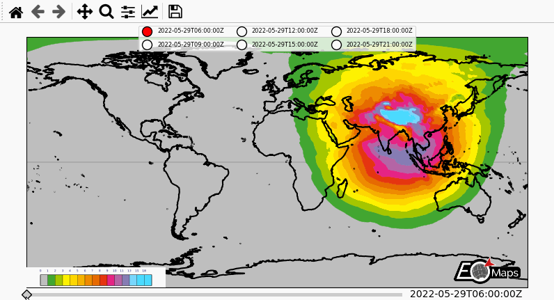
To show an example, here’s how to fetch multiple timestamps for the UV-index of the Copernicus Airquality service. (provided by https://atmosphere.copernicus.eu/)
from eomaps import Maps
import pandas as pd

m = Maps(layer="all", figsize=(8, 4))
m.subplots_adjust(left=0.05, right=0.95)
m.all.add_feature.preset.coastline()
m.add_logo()

layer = m.add_wms.CAMS.add_layer.composition_uvindex_clearsky
timepos = layer.wms_layer.timepositions   # available time-positions
all_styles = list(layer.wms_layer.styles) # available styles

# create a list of timestamps to fetch
start, stop, freq = timepos[1].split(r"/")
times = pd.date_range(start, stop, freq=freq.replace("PT", ""))
times = times.strftime("%Y-%m-%dT%H:%M:%SZ")

style = all_styles[0]     # use the first available style
for time in times[:6]:
    # call the layer to add it to the map
    layer(time=time,
          styles=[style],   # provide a list with 1 entry here
          layer=time        # put each WebMap on an individual layer
          )

layer.add_legend()  # add a legend for the WebMap service

# add a "slider" and a "selector" widget
m.util.layer_selector(ncol=3, loc="upper center", fontsize=6, labelspacing=1.3)
m.util.layer_slider()

# attach a callback to fetch all layers if you press l on the keyboard
cid = m.all.cb.keypress.attach.fetch_layers(key="l")
# fetch all layers so that they are cached and switching layers is fast
m.fetch_layers()
m.show_layer(times[0])      # make the first timestamp visible