🛰 WebMap layers
How to add WebMap services to a map
WebMap services (TS/WMS/WMTS) can be attached to the map via Maps.add_wms()
m.add_wms.attach.< SERVICE > ... .add_layer.< LAYER >(...)
< SERVICE > hereby specifies the pre-defined WebMap service you want to add,
and < LAYER > indicates the actual layer-name.
m = Maps(Maps.CRS.GOOGLE_MERCATOR) # (the native crs of the service)
m.add_wms.OpenStreetMap.add_layer.default()
A collection of open-access WebMap services that can be added to the maps. |
Note
It is highly recommended (and sometimes even required) to use the native crs of the WebMap service in order to avoid re-projecting the images (which degrades image quality and sometimes takes quite a lot of time to finish…)
most services come either in
epsg=4326or inMaps.CRS.GOOGLE_MERCATORprojection
from eomaps import MapsGrid
mg = MapsGrid(crs=Maps.CRS.GOOGLE_MERCATOR)
mg.join_limits()

mg.m_0_0.add_wms.OpenStreetMap.add_layer.default()
mg.m_0_1.add_wms.OpenStreetMap.add_layer.stamen_toner()

mg.m_1_1.add_wms.S1GBM.add_layer.vv()

# ... for more advanced
layer = mg.m_1_0.add_wms.ISRIC_SoilGrids.nitrogen.add_layer.nitrogen_0_5cm_mean
layer.set_extent_to_bbox() # set the extent according to the boundingBox
layer.info                 # the "info" property provides useful information on the layer
layer()                    # call the layer to add it to the map
layer.add_legend()         # if a legend is provided, you can add it to the map!
Pre-defined WebMap services
Global:
OpenStreetMap WebMap layers https://wiki.openstreetmap.org/wiki/WMS |
|
ESA Worldwide land cover mapping https://esa-worldcover.org/en |
|
NASA Global Imagery Browse Services (GIBS) https://wiki.earthdata.nasa.gov/display/GIBS/ |
|
Interface to the ISRIC SoilGrids database https://www.isric.org |
|
European Environment Agency Discomap services https://discomap.eea.europa.eu/Index/ |
|
Interface to the ERSI ArcGIS REST Services Directory http://services.arcgisonline.com/arcgis/rest/services |
|
Sentinel-1 Global Backscatter Model https://researchdata.tuwien.ac.at/records/n2d1v-gqb91 |
|
Global cloudless Sentinel-2 maps, crafted by EOX https://s2maps.eu/ |
|
Global ocean & land terrain models https://www.gebco.net/ |
|
Global Multi-Resolution Topography (GMRT) Synthesis https://gmrt.org/ |
|
Datasets from University of Maryland, Global Land Analysis and Discovery Team https://glad.umd.edu/ |
|
Copernicus Atmosphere Monitoring Service (Global and European) https://atmosphere.copernicus.eu/ |
|
WebMap services hosted by DLR's EOC Geoservice https://geoservice.dlr.de |
|
Planetary layers (Moon & Mars) provided by OpenPlanetary https://www.openplanetary.org |
Services specific for Austria (Europe)
|
Basemap for Austria https://basemap.at/ |
|
Basemaps for the city of Vienna (Austria) https://www.wien.gv.at |
Note
Services might be nested directory structures!
The actual layer is always added via the add_layer directive.
m.add_wms.<...>. ... .<...>.add_layer.<LAYER NAME>()
Some of the services dynamically fetch the structure via HTML-requests. Therefore it can take a short moment before autocompletion is capable of showing you the available options! A list of available layers from a sub-folder can be fetched via:
m.add_wms.<...>. ... .<LAYER NAME>.layers
Using custom WebMap services
It is also possible to use custom WMS/WMTS/XYZ services.
(see docstring of get_service() for more details and examples)
Get a object that can be used to add WMS, WMTS or XYZ services based on a GetCapabilities-link or a link to a ArcGIS REST API |
m = Maps()
# define the service
service = m.add_wms.get_service(<... link to GetCapabilities.xml ...>,
                                service_type="wms",
                                res_API=False,
                                maxzoom=19)
# once the service is defined, you can use it just like the pre-defined ones
service.layers   # >> get a list of all layers provided by the service

# select one of the layers
layer = service.add_layer. ... .< LAYER >
layer.info                  # >> get some additional infos for the selected layer
layer.set_extent_to_bbox()  # >> set the map-extent to the bbox of the layer

# call the layer to add it to the map
# (optionally providing additional kwargs for fetching map-tiles)
layer(...)
Setting date, style and other WebMap properties
Some WebMap services allow passing additional arguments to set properties such as the date or the style of the map. To pass additional arguments to a WebMap service, simply provide them when when calling the layer, e.g.:
m = Maps()
m.add_wms.< SERVICE >. ... .add_layer.< LAYER >(time=..., styles=[...], ...)
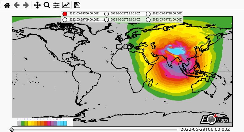
To show an example, here’s how to fetch multiple timestamps for the UV-index of the Copernicus Airquality service. (provided by https://atmosphere.copernicus.eu/)
from eomaps import Maps
import pandas as pd

m = Maps(layer="all", figsize=(8, 4))
m.subplots_adjust(left=0.05, right=0.95)
m.all.add_feature.preset.coastline()
m.add_logo()

layer = m.add_wms.CAMS.add_layer.composition_uvindex_clearsky
timepos = layer.wms_layer.timepositions   # available time-positions
all_styles = list(layer.wms_layer.styles) # available styles

# create a list of timestamps to fetch
start, stop, freq = timepos[1].split(r"/")
times = pd.date_range(start, stop, freq=freq.replace("PT", ""))
times = times.strftime("%Y-%m-%dT%H:%M:%SZ")

style = all_styles[0]     # use the first available style
for time in times[:6]:
    # call the layer to add it to the map
    layer(time=time,
          styles=[style],   # provide a list with 1 entry here
          layer=time        # put each WebMap on an individual layer
          )

layer.add_legend()  # add a legend for the WebMap service

# add a "slider" and a "selector" widget
m.util.layer_selector(ncol=3, loc="upper center", fontsize=6, labelspacing=1.3)
m.util.layer_slider()

# attach a callback to fetch all layers if you press l on the keyboard
cid = m.all.cb.keypress.attach.fetch_layers(key="l")
# fetch all layers so that they are cached and switching layers is fast
m.fetch_layers()
m.show_layer(times[0])      # make the first timestamp visible